Back Кармартэншыр Byelorussian Кармартъншър Bulgarian Sir Gaerfyrddin Breton Sir Gaerfyrddin Catalan Carmarthenshire CEB Carmarthenshire Czech Sir Gaerfyrddin Welsh Carmarthenshire German Carmarthenshire Spanish Carmarthenshire Estonian
Carmarthenshire
Sir Gaerfyrddin (Welsh) | |
|---|---|
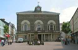
 Guildhall Square and Carmarthen Guildhall | |
| Motto(s): | |
 Carmarthenshire shown within Wales | |
| Coordinates: 51°51′22″N 4°18′38″W / 51.85611°N 4.31056°W | |
| Sovereign state | United Kingdom |
| Country | Wales |
| Preserved county | Dyfed |
| Incorporated | 1 April 1996 |
| Administrative HQ | County Hall, Carmarthen |
| Government | |
| • Type | Principal council |
| • Body | Carmarthenshire County Council |
| • Control | Plaid Cymru |
| • MPs | 2 MPs
|
| • MSs | 3 MSs
|
| Area | |
| • Total | 920 sq mi (2,370 km2) |
| • Rank | 3rd |
| Population (2022)[2] | |
| • Total | 189,117 |
| • Rank | 4th |
| • Density | 200/sq mi (80/km2) |
| Welsh language (2021) | |
| • Speakers | 39.9% |
| • Rank | 4th |
| Time zone | UTC+0 (GMT) |
| • Summer (DST) | UTC+1 (BST) |
| ISO 3166 code | GB-CMN |
| GSS code | W06000010 |
| Website | www |
Carmarthenshire (/kərˈmɑːrðənʃər, -ʃɪər/;[4] Welsh: Sir Gaerfyrddin [siːr gɑːɨrˈvərðɪn] or informally Sir Gâr) is a county in the south-west of Wales. The three largest towns are Llanelli, Carmarthen and Ammanford. Carmarthen is the county town and administrative centre. The county is known as the "Garden of Wales" and is also home to the National Botanic Garden of Wales.
Carmarthenshire has been inhabited since prehistoric times. The county town was founded by the Romans, and the region was part of the Kingdom of Deheubarth in the High Middle Ages. After invasion by the Normans in the 12th and 13th centuries it was subjugated, along with other parts of Wales, by Edward I of England. There was further unrest in the early 15th century, when the Welsh rebelled under Owain Glyndŵr, and during the English Civil War.
Carmarthenshire is mainly an agricultural county, apart from the southeastern part which was once heavily industrialised with coal mining, steel-making and tin-plating. In the north of the county, the woollen industry was very important in the 18th century. The economy depends on agriculture, forestry, fishing and tourism. West Wales was identified in 2014 as the worst-performing region in the United Kingdom along with the South Wales Valleys with the decline in its industrial base, and the low profitability of the livestock sector.[5]
Carmarthenshire, as a tourist destination, offers a wide range of outdoor activities. Much of the coast is fairly flat; it includes the Millennium Coastal Park, which extends for 10 miles (16 km) to the west of Llanelli; the National Wetlands Centre; a championship golf course; and the harbours of Burry Port and Pembrey. The sandy beaches at Llansteffan and Pendine are further west. Carmarthenshire has a number of medieval castles, hillforts and standing stones. The Dylan Thomas Boathouse is at Laugharne.
- ^ "Council & Democracy". Carmarthenshire County Council. Retrieved 6 August 2024.
- ^ a b "Mid-Year Population Estimates, UK, June 2022". Office for National Statistics. 26 March 2024. Retrieved 3 May 2024.
- ^ "How life has changed in Carmarthenshire: Census 2021". Office for National Statistics. 19 January 2023. Retrieved 6 August 2024.
- ^ "Carmarthenshire", British & World English Dictionary, Oxford Dictionaries Online
- ^ "West Wales the worst performing economy in the UK". Carmarthen Journal. 10 December 2014. Retrieved 16 December 2018.
